Le Bois Debout - Gravure anciennes et modernes
Language:
English
English
Français
English
Français
Currency:
EUR €
EUR €
USD $
EUR €
USD $
Sign in
Search
shopping_cart
Cart
(0)
Botanicals
Maps
Decorative patterns
Contemporary prints
Food prints
Japanese woodblocks
Fruits
Medecine
Others categories
Aquarelles, dessins
Architecture
Decorative patterns
Caricature
Dogs and cats
Hunting
Shells
Miscellaneous
Empire
Children and games
Fencing
19 th century prints
Ethnology and mythology
Professions
Military
Nudes
Birds
Orientalism
Fishing
Fishes
Regionalism (No french)
French regionalism
Transport
Views of Lyon (Originals)
Views of Lyon (Reprints)
Aquarelles Vietnamiennes contemporaines
Home
Others categories
French regionalism
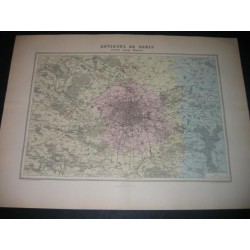
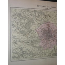
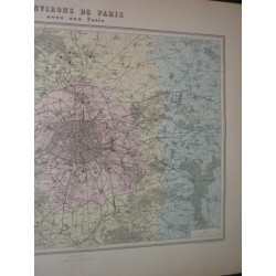
Map of Paris
Map of Paris
€20.00
Tax included
Reference
bd220409a_1
Map of Paris and suroundings. Map in color from the end of the 19th century....
Date :
1890
Author :
Anonym
Marks :
20.44 X 15.72 inch
Quantity
Add to cart
In Stock
Share
Share
Tweet
Pinterest
Description
Product Details
Map of Paris and suroundings. Map in color from the end of the 19th century.
Date of publication :
1890
Author :
Anonym
Sheet marks :
20.44 inch X 15.72 inch
Plate marks :
16.9 inch X 11.4 inch
Brand
anonym
Reference
bd220409a_1
Map of Paris and suroundings. Map in color from the end of the 19th century....
Date :
1890
Author :
Anonym
Marks :
20.44 X 15.72 inch